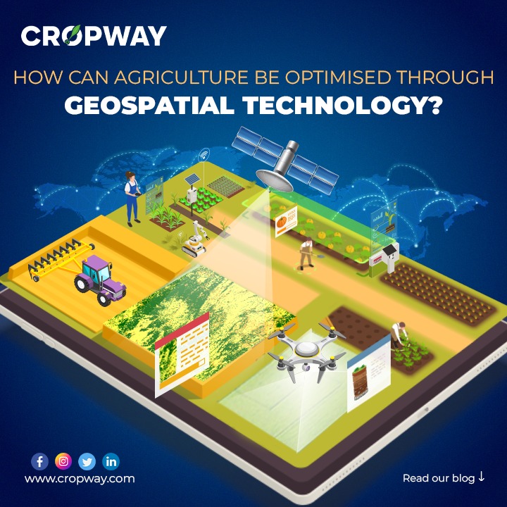
In today’s ever-evolving agricultural landscape, technology plays a pivotal role in driving efficiency, sustainability, and overall productivity. The heart of agriculture lies in the land itself, an unchanging asset for farmers. But what if there was a way to maximize its yield potential without depleting it? The answer to this question lies in a new era of agricultural technology.
With automation, the integration of IoT devices, GIS tools, and drones, farmers can explore their land from fresh perspectives, optimizing it for bountiful harvests. Furthermore, the introduction of smart tractors, agricultural bots, and different sensors revolutionizes the way agricultural processes are conducted, both in the fields and throughout the journey from farm to market. In an industry historically characterized by slim profit margins, agriculture is on the brink of a transformative shift. It’s harnessing the power of data and embracing precision agriculture technology to unlock previously untapped value. One such technology that is making a significant impact is geospatial technology, which encompasses the use of location-based data and GPS systems to enhance various aspects of farming.
Let’s dive deeper into how innovative technologies are shaping the landscape of agriculture:
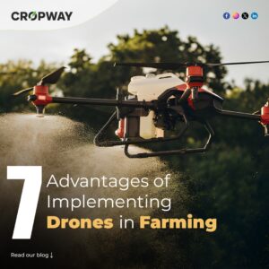
Unmanned Aerial Vehicles (UAVs) For Optimised Agriculture Productivity
They are autonomous flying machines capable of operating without human pilots. This category encompasses a wide variety of robotic aircraft, including drones, micro-sized, and nano-sized aerial vehicles. These devices are capable of aerial movement thanks to their onboard control systems that manage both lift and thrust propulsion mechanisms.
Aerial inspections used to come at a hefty price, costing up to a whopping $1,000 per hour for chartering a plane. But here’s the game-changer – drones. These unmanned aerial vehicles are your affordable, immediate, and smart eyes over vast stretches of farmland. They have emerged as invaluable allies, offering a myriad of benefits to farmers. They’re available for charter and data collection at a fraction of the cost. These versatile aerial devices serve as a multi-faceted solution for optimizing farming practices.
Drones conduct thorough crop health assessments, pinpointing areas affected by weeds, infections, and pests, allowing for prompt intervention. They aid in creating precise treatment plans to enhance crop vitality and yield. With their watchful eyes, drones continuously track plant growth, providing real-time data crucial for decision-making. Moreover, the capabilities of drones extend to essential tasks like field mapping, crop rotation planning, and efficient weeding operations. They’re instrumental in precise crop spraying, optimizing resource utilization. Beyond these functions, drones empower farmers to streamline their processes, obtain crucial crop insights, surpass harvest goals, and maximize yields while conserving resources.
Drones in agriculture come in various forms, each tailored to specific needs. For example:
- Fixed-wing drones cover extensive land areas.
- Rotary drones streamline operational processes.
- Drones equipped with multispectral sensors detect and address issues like weeds, infections, and pests.
Mapping drone technology further assists farmers by identifying areas in need of focused attention. With drones as their high-flying partners, farmers are redefining the art of cultivation, embracing efficiency, and reaping the rewards of modern technology.
Collection And Interpretation of Agricultural Data For Geospatial:
Efficient collection and assessment of pertinent data are essential for the successful application of geospatial technology. Various approaches have been devised to achieve this objective, with remote sensing being a predominant method. Each distinct area presents its own specific demands that necessitate the utilization of GIS and GPS technologies. Consequently, the initial step in precision agriculture is the segmentation of land into management zones. This division of land into zones primarily relies on factors like soil types, pH levels, pest presence, nutrient availability, soil moisture levels, fertility needs, weather forecasts, crop characteristics, and hybrid performance to delineate these zones.
Earth scientists have access to a diverse array of satellite remote sensing data, including sources like Landsat OLI, IRS-P6, Cartosat-I, Cartosat-II, QuickBird, Sentinel-2, and Google. These datasets serve as valuable resources for constructing spatial databases related to natural resources, catering to a wide range of applications. However, it’s important to note that remote sensing data alone may not encompass all the necessary information for a comprehensive assessment of soil and land resources. To address this, a holistic approach involves integrating field surveys and supplementary data from various sources with remote sensing information.
One such popular data collection method involves drones. Farmers can program pre-planned flight routes, enabling UAVs to capture critical data as frequently as needed. They’re like vigilant sentinels patrolling your fields, collecting a treasure trove of information.
- NDVI Data: Drones provide the essential Normalized Difference Vegetation Index (NDVI) data, offering insights into plant health and allowing farmers to gauge biomass on a grand scale.
- GPS Coordinates: Pinpointing the exact location of fields and other points of interest, from pest-infested areas to under-irrigated patches.
- Soil Insights: Determining nitrogen levels in the soil, a key factor in successful crop growth.
- IoT Sensors: These smart sensors, strategically placed on the ground and within farm equipment, usher in a new era of automation and data-driven decision-making.
Internet of Things (IoT) for Agricultural Advancements:
Automation is no stranger to farming, but the IoT is opening doors to a fresh chapter in precision agriculture technology. For instance, it serves as a solution for device connectivity and data acquisition. In agricultural settings, it is used to oversee parameters like humidity, temperature, soil conditions, rainfall, fertilizer usage, and storage.
Leveraging IoT technology can enhance productivity while keeping costs in check. By establishing connections between actuators, multiple sensors, controllers, and servers via the internet, farmers can subsequently gain the ability to remotely monitor fields. They have the choice of receiving data manually or as automated alert responses. Moreover, AI-driven analytical and predictive models are employed to analyze data collected from IoT devices, facilitating the monitoring of crops, field surveys, stress detection, environmental condition forecasting, and crop yield estimation.
IoT sensors in the fields are the farmers’ eyes and ears, providing critical data on a range of factors:
- Fertilizer and Pesticide Allocation: Precise guidance on the right amount and location for these crucial inputs.
- Crop Health: Real-time updates on the well-being of your plants.
- Moisture and Soil Quality: Vital information to optimize irrigation and soil management.
- Greenhouse Conditions: Monitoring light, temperature, and humidity levels to create the perfect environment for crops.
- Harvest Timing: Pinpointing the optimal moment to reap the rewards of your hard work.
Conclusion
The emergence of promising technologies like geospatial, big data, AI, IoT, and cloud computing heralds a bright future with the potential to make significant contributions to agriculture. The amalgamation of geospatial technologies with data science methods holds immense promise for the spatiotemporal analysis of land resources and land transformation processes. This, in turn, aids in planning and managing these resources for their optimal utilization, ultimately leading to sustained production levels and enhanced food security. This comprehensive approach not only ensures productivity but also promises cost reduction, safeguarding the environment as we step into a greener and more productive era with smarter fields.
References
- (GP Obi Reddy, 2023) Smart Agriculture For Developing Nations, Status, Perspectives and Challenges. Journal article
- GIS in Agriculture EOS BLOG
- (Anjna Gupta, R.L Raut and Hansnath, Vol. 3 Issue-8, April 2023) Role of Geospatial Technology in Agriculture. Journal article
You might also want to read:-Decoding Climate-Smart Agriculture